科研动态Research News | 我院刘桂林副研究员团队在农产品地理标志空间模拟领域取得研究进展
华南师范大学地理科学学院/学院新闻2022-10-31 13:20:10来源:华南师范大学评论:0点击:收藏本文
刘桂林副研究员团队在农产品地理标志空间模拟领域取得研究进展
Associate Prof. Dr. Guilin Liu’s team makes research progress in spatial simulation of geographical indications of agricultural products
华南师范大学地理科学学院刘桂林副研究员(通讯作者)及农业遥感团队成员:冼宇阳、姚惠宗、钟丽明在Journal of Cleaner Production及Geocarto International发表题为“Will citrus geographical indications face different climate change challenges in China?” (https://doi.org/10.1016/j.jclepro.2022.131885)与“Predicting the current and future distributions of major food crop designated geographical indications (GIs) in China under climate change” (https://doi.org/10.1080/10106049.2021.1993352)的研究论文。
农产品地理标志(Geographical Indication, GI)是乡村振兴及可持续发展政策工具,广泛受到经济、农学、地学诸多领域学者、政府、企业、农户的广泛关注。农产品地理标志是指农产品来源于特定地域,其品质与产地的自然环境和人文历史因素相关,并以地域与产品名称冠名。其具有多重属性(如地理位置、降水、温度、农业文明、品种性状、政策和政府支持、国际贸易、知识产权等),并衍生出经济、文化与生态功能等多种功能(图1)。目前,巴西、土耳其、越南、印度等诸多国家均将农产品地理标志用作乡村经济复苏及生计转型的政策工具(Medeiros et al., 2019; Jena et al., 2010; Hoang et al., 2020)。
农作物会受到气候因素的影响,未来气候变化情景如何影响有地理标志的农产品的时空布局?因此,刘桂林博士的农业遥感团队针对作物品种属性,在共享社会经济路径(Shared Socio-economic Pathways, SSPs)下,利用机器学习模型模拟与GIS空间分析开展了系列研究。分析了2020—2100年不同气候变化情景对柑橘类水果、粮食作物的潜在气候适宜性及适宜区时空变化。结果发现:(1)柑橘类GI适宜区域向北移动,在南亚热带湿润区减少,而在北亚热带湿润区增加;(2)水稻、小麦、玉米、土豆、小米等主粮均北移。中国东北地区的水稻、小麦、大豆和马铃薯的潜在气候适宜生境呈现上升趋势;西北地区小麦的潜在气候适宜性栖息地逐渐增加。研究结果为今后的农业布局及乡村规划,提供数据支撑与科学建议。同时,对于高品质的水果等非粮农作物地理标志而言,如何平衡其与 “耕地非粮化政策之间关系,也是今后国土空间规划需要关注的重点。
本研究得到了国家自然科学基金(41901349)、广东省科技计划项目(2021B1111610001)、广东省普通高校青年创新人才类项目(2018KQNCX054)、华南师范大学青年拔尖科研启动项目(8S0472)等项目的支持。Journal of Cleaner Production是绿色和可持续科技等领域的权威期刊,2021年影响因子为11.072,5年影响因子为11.016,全球排名:5/47(GREEN & SUSTAINABLE SCIENCE & TECHNOLOGY)。
Geographical Indication for agricultural products is a policy tool for the rural revitalization and sustainable development, which has received widespread attention from scholars, governments, enterprises and farmers in fields of economics, agronomy and geography. GI refers to agricultural products originating from a specific region, whose quality is related to the natural environment and human and historical factors of the place of origin, and is named after the region and the name of the product. Some specific quality, reputation or other traits of the product can be attributed to the geographical origin in essence. GIs of agricultural products have multiple attributes (e.g., geographic location, precipitation, temperature, agricultural civilization, crop species traits, related policy and government support, international trade, and intellectual property rights, etc.) and derives multiple functions such as economic, cultural and ecological functions (Figure 1). Currently, many countries such as Brazil, Turkey, Vietnam and India are using GIs of agricultural products as a policy tool for rural economic recovery and livelihood transformation (Medeiros et al., 2019; Jena et al., 2010; Hoang et al., 2020).
Agricultural products are directly influenced by climatic factors. How will future climate change affect spatiotemporal patterns of agricultural products with geographical indications? To address this scientific question, Dr. Liu Guilin's team constructed a machine learning model specific to the crop variety attribute. Then they used GIS spatial analysis and model simulations under the Shared Socio-Economic Pathway (SSP) scenarios to analyze the potential climate suitability/suitability zones and their dynamics in space and time for citrus fruits and grain crops under different climate change scenarios from 2020-2100. The results found that: (1) citrus GI suitability zones shift northwards, decreasing in the humid southern subtropical zone and increasing in the humid northern subtropical zone; (2) staple grains such as rice, wheat, maize, potatoes and millet all shift northwards. Potential climatically suitable habitats for rice, wheat, soybean and potato in northeast China showed an increasing trend. Similarly, an increasing trend of climatically suitable habitats for wheat was observed in northwest China. This study can provide scientific evidence and data support for future agricultural layout and rural planning. Meanwhile, balancing relationships between non-food crop GIs such as high-quality fruits and "the policy of non-foodization of arable land" is critical for future territorial spatial planning.
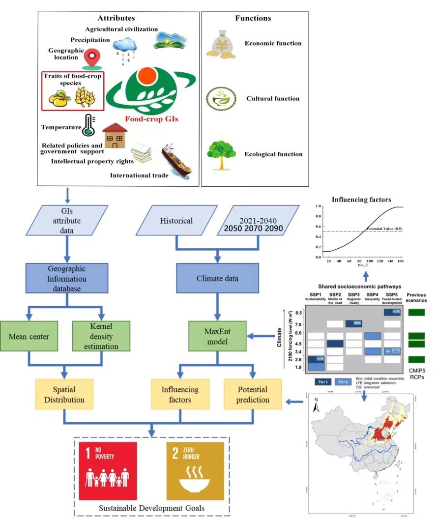
农作物地理标志属性/功能示意图及技术路线
文案编辑 | 刘桂林
初审 | 袁亚娟
复审 | 陶伟
终审 | 刘云刚
标签: