科研动态 Research News | 我院舒娱琴教授在地球科学综合SCI期刊上发表研究成果
华南师范大学地理科学学院/学院新闻2022-11-22 00:04:05来源:华南师范大学评论:0点击:收藏本文
舒娱琴教授在地球科学综合SCI期刊Phys. Chem. Earth发表研究成果
Prof. Yuqin Shu has published her research outputs in Phys. Chem. Earth, a comprehensive journal in Geoscience
近期,我院舒娱琴教授以第一作者在地球科学综合SCI期刊Physics and Chemistry of the Earth 发表题为“Application of Multiple Geographical Units Convolutional Neural Network based on neighborhood effects in urban waterlogging risk assessment in the city of Guangzhou, China”的研究论文。
近年来,受极端气候影响,我国大部分城市暴雨频发,城市内涝问题及次生灾害不断加重,造成了严重的社会经济损失甚至人员伤亡。广州市作为我国一线城市,不仅是人口集聚中心,也是经济、社会发展的重要区域,所受内涝灾害的影响很深。因此,开展广州市主城区内涝风险评估研究不仅有助于探索内涝灾害发生的内在规律,也将为该区域制定防灾减灾措施以及相关应急管理预案提供理论指导与科学依据,能够有效提高城市内涝防治的决策水平。
本文基于卷积神经网络方法,充分考虑相邻栅格的空间相关性,借助Tensorflow平台构建了多地理单元的卷积神经网络(Multiple Geographical Units Convolutional Neural Network,MGCNN)的城市内涝风险评估模型。模型中选取高程、坡度、高程标准差、归一化植被指数、归一化建筑指数、修正归一化水体指数以及基于灰度共生矩阵(Grey Level Co-Occurrence Matrix, GLCM)的熵、能量、对比度、相关性共计10个空间指标。通过对空间指标进行数据融合与转换,并输入到的城市内涝风险评估模型进行训练。与现有城市内涝风险评估研究相比,本文首次将基于GLCM的遥感影像的纹理特征引入到内涝风险评估研究中。研究表明:看似简单的纹理特征如对比度、相关性也能在内涝风险区域的识别中起到积极作用。区别于目前用于内涝风险评估研究的机器学习模型,本文从空间相关性出发,重点考虑了邻域栅格的影响,所提出的MGCNN模型在一定程度上提高了机器学习算法即黑匣子模型的可解释性,城市内涝风险的评估准确率也得到了明显的改善。
Physics and Chemistry of the Earth是地球科学综合SCI期刊,5年影响因子为3.419。
Waterlogging has recently occurred in cities across China, causing serious economic and property losses. It is imperative to assess the susceptibility of cities to waterlogging, especially those in urban areas, to reduce the damages caused by waterlogging. Artificial Neural Network algorithms have been used to assess the hazards of waterlogging because of their simplicity, objectivity and efficiency. Considering the neighborhood effects, this research proposes an integrated Multiple Geograpical Units Convolutional Neural Network (MGCNN) model for assessing the waterlogging risk in the primarily urban area of Guangzhou, China. Ten spatial factors were considered to be added to the MGCNN, which are DEM, Slope, Std, NDVI, NDBI, MNDWI, Entropy, Contrast, Correlation and Energy based on a Gray-level Co-occurrence Matrix (GLCM). The results show that: 1) the texture features of remote sensing image plays an important role in the identification of urban waterlogging area through significance analysis of the ten impact factors; 2) the accuracy rate of the MGCNN trained with the input data of the four risk levels is higher than 0.88, while the maximum accuracy rate of the two risk levels is only about 0.6; 3) the MGCNN has a lower cross-entropy loss value of 0.82 than the SGCNN of 1.13 after 20,000 iterations of training; 4) The Area Under the Curve (AUC) value of the MGCNN was about 0.95, highest among the MGCNN,SGCNN, SVM-BRF and SVM-Poly models; 5) Extremely high risk areas for waterlogging were mainly found in low-lying areas with a high density of urban buildings, including the Yuexiu district, the northern Liwan district, the central and southern sections of the Tianhe district, and the western Haizhu district. Therefore, fully considering neighborhood effects of the surrounding geographical units, the constructed MGCNN model improves not only the accuracy but also the interpretability of the black box.
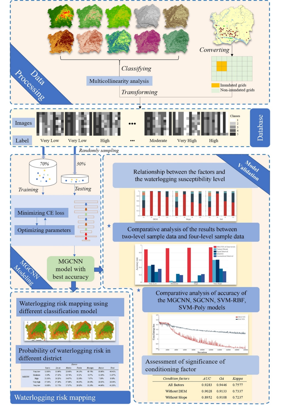
图1 技术路线图
文字 | 舒娱琴
初审 | 袁亚娟
复审 | 陶 伟
终审 | 刘云刚
标签: