科研动态Research News | 我院丁浒特聘研究员、付迎春教授在地貌学领域TOP期刊发表学术论文
华南师范大学地理科学学院/学院新闻2023-09-06 15:18:00来源:华南师范大学评论:0点击:收藏本文
我院丁浒特聘研究员、付迎春教授在Earth Surface Processes and Landforms发表学术论文
Dr. Hu Ding and Prof. Yingchun Fu have published the research in Earth Surface Processes and Landforms, a top journal in geomorphology.
作者简介

丁浒,华南师范大学地理科学学院特聘研究员。主要研究领域包括数字地形分析,数字地貌制图等方面。主持国家自然科学基金,广东省自然科学基金,中国博士后科学基金等项目,近年来相关成果发表在ESPL, IJDE, Transactions in GIS, Remote Sensing, Geomorphology等国内外权威期刊。
付迎春,华南师范大学地理科学学院教授,博士生导师,地理信息学科学系主任。主要研究领域包括高分辨率时序遥感影像智能计算、城市与湿地遥感大数据与可持续发展等。近三年主持国家自然科学基金面上项目,广东省海洋发展中心示范项目等,《Journal of Remote Sensing》专刊编辑。近年来在Remote Sensing of Environment, IEEE JSTARS, Science of the Total Enviroment, Jounal of Geographical Science, 遥感学报, 自然资源学报 等国内外权威期刊发表学术论文,获全国高校GIS教学成果奖一等奖。

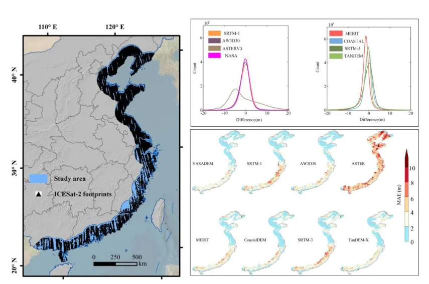
近日,华南师范大学地理科学学院丁浒特聘研究员(第一作者)、付迎春教授(通讯作者)、南京林业大学那嘉明博士和本科生导师制团队成员(杨思行,刘俊壕,罗钧行,刘意,梁欣怡等同学)在地貌学领域TOP期刊Earth Surface Processes and Landforms发表研究论文Performance assessment of global open-access digital elevation models in China mainland coastal region. (全文链接:https://doi.org/10.1002/esp.5677 )
数字高程模型(Digital elevation models, DEMs)是进行沿海生态系统监测的重要基础数据集,近年来已发布的众多可公开获取的DEM为海岸带相关研究提供了重要的数据支撑。但现有研究尚未能在沿海地区对这些已公开的DEM数据进行全面的精度评估,从而为海岸带相关研究提供高程数据使用方面的建议。在此背景下,本研究以激光测高数据ICESat-2作为精度评估的参考数据,以中国大陆沿海地区为研究区,面向SRTM-3、SRTM-1、TanDEM-X、ASTER GDEM v3、MERIT DEM、AW3D30、NASADEM和CoastalDEM等八个全球尺度公开DEM数据集进行了全面的精度评价。在评价指标方面,本研究选择了平均绝对误差(MAE)和均方根误差(RMSE)等用来描述数据误差,并进行了数据误差的空间分布分析。并进一步分析了高程、坡度、地貌形态、地貌成因和土地利用对垂直精度的影响,以评估DEM的适用性。实验结果显示,CoastalDEM具有最高的垂直精度,其MAE和RMSE分别为1.68米和2.55米。NASADEM是垂直精度最高的30米分辨率DEM,MAE和RMSE分别为1.88米和2.61米。其他精度接近的DEM包括AW3D30、SRTM-1、MERIT和SRTM-3 DEM。结果表明,CoastalDEM优于其他数据集,表明其在沿海地区的适用性。
Earth Surface Processes and Landforms期刊主要关注地表过程与地貌,是地理科学和地貌学领域的国际权威期刊,2022年影响因子为3.3 (Q2),5年影响因子为3.9.
Abstract: Digital elevation models (DEMs) are the fundamental datasets for coastal ecosystem monitoring, and several global open-accessed DEMs have recently been reported. In coastal regions, a comprehensive vertical accuracy assessment of these DEMs has not yet been carried out. In this study, eight open-access DEM datasets, including SRTM-3, SRTM-1, TanDEM-X, ASTER GDEM v3, MERIT DEM, AW3D30, NASADEM, and CoastalDEM, were investigated across the coastal region of the Chinese mainland using high accuracy ICESat-2 data as a reference. Statistical tools including mean absolute error (MAE) and root mean square error (RMSE) were selected to describe the data error/uncertainty and spatial distribution. Moreover, the effects of elevation ranging, slope degree, geomorphogenesis and landuse on vertical accuracy were further analyzed to assess their applicability. The assessment results revealed that the CoastalDEM and NASADEM datasets had the highest accuracy, with MAE values of 1.68 m and 1.88 m and RMSE values of 2.55 m and 2.61 m, for 3-arc second and 1-arc second resolution DEMs, respectively. Other DEMs with close accuracies include AW3D30, SRTM-1, MERIT and SRTM-3 DEM. The results proved that the CoastalDEM outperformed other datasets, indicating its applicability in coastal regions.
Graphic Abstract
文字编辑 | 丁浒 付迎春
初审 | 袁亚娟
复审 | 陶 伟
终审 | 刘云刚
标签: